|
No. |
District |
Birth Year |
Forest Type |
Treatment |
Acres |
Name |
|
1 |
Tallulah |
07 |
41 |
Insecticide only |
18 |
Burrells Ford 1 |
|
2 |
Tallulah |
00 |
4 |
Insecticide only |
7 |
Burrells Ford 2 |
|
3 |
Tallulah |
20 |
41 |
Insecticide and Beetle Release |
331 |
Cedar Cliff |
|
4 |
Tallulah |
1890 |
41 |
Insecticide and Beetle Release |
227 |
Hicks/Ridley/Reed |
|
5 |
Tallulah |
0 |
0 |
Insecticide and Beetle Release |
97 |
Clear Creek |
|
6 |
Tallulah |
1923 |
41 |
Insecticide and Beetle Release |
1291 |
Reed Mill Creek |
|
7 |
Tallulah |
1895 |
4 |
Insecticide and Beetle Release |
62 |
Mose Branch |
|
8 |
Tallulah |
1980 |
41 |
Insecticide and Beetle Release |
544 |
Holcomb Creek |
|
9 |
Tallulah |
1920 |
41 |
Insecticide and Beetle Release |
121 |
Billingsley Creek |
|
10 |
Tallulah |
1942 |
41 |
Insecticide and Beetle Release |
42 |
Goldmine Branch |
|
11 |
Tallulah |
0 |
0 |
Insecticide and Beetle Release |
300 |
Walnut Fort |
|
12 |
Tallulah |
0 |
0 |
Insecticide and Beetle Release |
197 |
Ramey Creek |
|
13 |
Tallulah |
1920 |
41 |
Insecticide and Beetle Release |
46 |
Pool Creek |
|
14 |
Tallulah |
1922 |
41 |
Insecticide only |
19 |
Darnell Creek |
|
15 |
Tallulah |
1910 |
41 |
Insecticide and Beetle Release |
79 |
Finney Creek |
|
16 |
Tallulah |
1936 |
41 |
Insecticide and Beetle Release |
596 |
Keener Creek |
|
17 |
Tallulah |
1877 |
8 |
Insecticide only |
12 |
Racepath |
|
18 |
Tallulah |
1928 |
41 |
Insecticide and Beetle Release |
198 |
Timpson Creek |
|
19 |
Tallulah |
1900 |
41 |
Insecticide and Beetle Release |
99 |
Stroud Mt. |
|
20 |
Tallulah |
1920 |
41 |
Insecticide and Beetle Release |
48 |
Upper Cliff Creek |
|
21 |
Tallulah |
0 |
0 |
Insecticide only |
4 |
Cliff Creek |
|
22 |
Tallulah |
1890 |
41 |
Insecticide and Beetle Release |
47 |
Muscadine |
|
23 |
Tallulah |
1900 |
41 |
Insecticide and Beetle Release |
397 |
Cliff Creek |
|
24 |
Tallulah |
1900 |
41 |
Insecticide and Beetle Release |
499 |
Stonewall |
|
25 |
Tallulah |
1908 |
41 |
Insecticide only |
22 |
Scott Creek |
|
26 |
Tallulah |
1900 |
41 |
Insecticide and Beetle Release |
50 |
Slick Shoals |
|
27 |
Tallulah |
1928 |
41 |
Insecticide and Beetle Release |
131 |
Crow Creek |
|
28 |
Tallulah |
1925 |
4 |
Insecticide and Beetle Release |
105 |
Falls Branch |
|
29 |
Chattooga |
1897 |
41 |
Insecticide and Beetle Release |
290 |
Panther Creek |
|
30 |
Chattooga |
1870 |
41 |
Insecticide and Beetle Release |
95 |
Weaver Creek |
|
31 |
Chattooga |
1880 |
41 |
Insecticide and Beetle Release |
218 |
Davidson Creek |
|
32 |
Chattooga |
1885 |
8 |
Insecticide only |
12 |
Raper Creek |
|
33 |
Chattooga |
1894 |
41 |
Insecticide only |
23 |
Broad River |
|
34 |
Tallulah |
1890 |
41 |
Insecticide and Beetle Release |
232 |
Coleman River |
|
35 |
Tallulah |
1951 |
41 |
Insecticide only |
18 |
Shock Branch |
|
36 |
Tallulah |
1928 |
41 |
Insecticide only |
17 |
Charlies Creek |
|
37 |
Tallulah |
1925 |
41 |
Insecticide and Beetle Release |
806 |
Tallulah River |
|
38 |
Tallulah |
1933 |
41 |
Insecticide and Beetle Release |
89 |
Nicholson Branch |
|
39 |
Brasstown |
0 |
0 |
Insecticide only |
99 |
Big John Creek |
|
40 |
Brasstown |
1920 |
41 |
Insecticide and Beetle Release |
4242 |
Scataway |
|
41 |
Brasstown |
1937 |
41 |
Insecticide and Beetle
Release |
7171 |
Bell Mtn |
|
42 |
Brasstown |
1974 |
41 |
Insecticide and Beetle
Release |
5858 |
Swallow Creek |
|
43 |
Brasstown |
1950 |
41 |
Insecticide and Beetle
Release |
3737 |
Hog Creek |
|
44 |
Brasstown |
0 |
0 |
Insecticide and Beetle
Release |
4444 |
Fodder Creek |
|
45 |
Brasstown |
0 |
0 |
Insecticide and Beetle
Release |
4747 |
Spaniard Branch |
|
46 |
Tallulah |
1920 |
41 |
Insecticide and Beetle Release |
174 |
Hemlock Falls |
|
47 |
Tallulah |
1910 |
41 |
Insecticide and Beetle Release |
87 |
Jessie Branch |
|
48 |
Brasstown |
1945 |
41 |
Insecticide and Beetle Release |
342 |
Corbin |
|
49 |
Chattooga |
1915 |
41 |
Insecticide and Beetle Release |
75 |
Hickory Nut Mt. |
|
50 |
Chattooga |
1885 |
41 |
Insecticide and Beetle Release |
68 |
Nester Creek |
|
51 |
Chattooga |
1899 |
41 |
Insecticide and Beetle Release |
240 |
York Creek |
|
52 |
Brasstown |
1940 |
41 |
Insecticide and Beetle Release |
303 |
High Shoals |
|
53 |
Brasstown |
0 |
0 |
Beetle Release Only |
173 |
Soapstone |
|
54 |
Brasstown |
0 |
0 |
Insecticide and Beetle Release |
45 |
Big Bald Cove |
|
56 |
Brasstown |
1921 |
41 |
Insecticide and Beetle Release |
143 |
Ivy log |
|
57 |
Brasstown |
0 |
|
Insecticide only |
12 |
Beasley |
|
58 |
Brasstown |
0 |
0 |
Insecticide and Beetle Release |
319 |
Bob Creek |
|
59 |
Chattooga |
1895 |
41 |
Insecticide and Beetle Release |
850 |
Chattahoochee River |
|
60 |
Chattooga |
0 |
0 |
Insecticide and Beetle Release |
76 |
Dukes Creek Falls |
|
62 |
Brasstown |
1910 |
41 |
Insecticide and Beetle Release |
171 |
Bowers Cove |
|
63 |
Brasstown |
0 |
0 |
Insecticide and Beetle Release |
168 |
Wolf Creek |
|
64 |
Brasstown |
0 |
0 |
Insecticide and Beetle Release |
275 |
Helton Creek |
|
65 |
Brasstown |
1910 |
41 |
Insecticide and Beetle Release |
46 |
Alec Cove |
|
66 |
Brasstown |
0 |
0 |
Insecticide and Beetle Release |
52 |
Lordamercy Cove |
|
67 |
Chattooga |
1940 |
41 |
Insecticide only |
16 |
|
|
68 |
Chattooga |
1910 |
41 |
Insecticide and Beetle Release |
120 |
Boggs Creek |
|
69 |
Brasstown |
0 |
0 |
Insecticide and Beetle Release |
88 |
Blood Mtn Cove |
|
70 |
Brasstown |
0 |
0 |
Insecticide and Beetle Release |
82 |
Tigue Branch |
|
71 |
Brasstown |
0 |
0 |
Insecticide and Beetle Release |
82 |
Slaughter Creek |
|
72 |
Brasstown |
0 |
0 |
Insecticide and Beetle Release |
33 |
Waters Creek |
|
73 |
Brasstown |
0 |
0 |
Insecticide and Beetle Release |
43 |
Dockery Lake |
|
74 |
Brasstown |
0 |
0 |
Insecticide and Beetle Release |
259 |
Coopers Creek |
|
75 |
Toccoa |
1925 |
41 |
Insecticide and Beetle Release |
154 |
Mulky Creek |
|
76 |
Brasstown |
0 |
0 |
Insecticide and Beetle Release |
43 |
Flowers Cove |
|
77 |
Brasstown |
0 |
0 |
Insecticide and Beetle Release |
119 |
Canada Creek -upper |
|
78 |
Brasstown |
0 |
0 |
Insecticide and Beetle Release |
257 |
Canada Creek- lower |
|
79 |
Toccoa |
0 |
0 |
Insecticide and Beetle Release |
88 |
Clements Branch |
|
80 |
Toccoa |
1905 |
4 |
Insecticide and Beetle Release |
259 |
Toccoa River |
|
81 |
Toccoa |
0 |
0 |
Insecticide and Beetle Release |
127 |
Little Rock Creek |
|
82 |
Toccoa |
0 |
0 |
Insecticide and Beetle Release |
157 |
Rock Creek |
|
83 |
Brasstown |
1910 |
8 |
Insecticide and Beetle Release |
66 |
Cochran Creek |
|
84 |
Brasstown |
0 |
0 |
Insecticide and Beetle Release |
132 |
Blackwell Creek |
|
85 |
Toccoa |
0 |
0 |
Insecticide and Beetle Release |
198 |
Flat Creek |
|
86 |
Toccoa |
1920 |
8 |
Insecticide and Beetle Release |
110 |
Stanley Creek |
|
87 |
Toccoa |
0 |
0 |
Insecticide only |
25 |
Cold Mountain |
|
88 |
Toccoa |
0 |
0 |
Insecticide and Beetle Release |
1104 |
Noontootla |
|
89 |
Toccoa |
1900 |
41 |
Insecticide and Beetle Release |
112 |
Montgomery Creek |
|
90 |
Toccoa |
0 |
0 |
Insecticide and Beetle Release |
228 |
Lance Creek |
|
91 |
Toccoa |
0 |
0 |
Insecticide and Beetle Release |
71 |
Cochrans Falls |
|
92 |
Toccoa |
1910 |
41 |
Insecticide and Beetle Release |
84 |
Anderson Creek L frk |
|
93 |
Toccoa |
0 |
0 |
Insecticide and Beetle Release |
64 |
Anderson Creek R frk |
|
94 |
Cohutta |
1981 |
41 |
Insecticide and Beetle Release |
34 |
Gibson Creek |
|
95 |
Cohutta |
1900 |
41 |
Insecticide only |
25 |
S. Fork Jacks River |
|
96 |
Cohutta |
1957 |
41 |
Insecticide and Beetle Release |
155 |
W. Fork Jacks River |
|
97 |
Cohutta |
1940 |
5 |
Insecticide and Beetle Release |
38 |
Mill Branch |
|
98 |
Cohutta |
1902 |
4 |
Insecticide and Beetle Release |
178 |
Upper Jacks |
|
99 |
Cohutta |
1939 |
41 |
Insecticide only |
15 |
Tumbling Creek South |
|
100 |
Cohutta |
1915 |
8 |
Insecticide and Beetle Release |
59 |
Tumbling Creek Central |
|
101 |
Cohutta |
1907 |
8 |
Insecticide and Beetle Release |
76 |
Tumbling Creek North |
|
102 |
Cohutta |
0 |
0 |
Insecticide and Beetle Release |
128 |
Penitentiary Branch |
|
103 |
Cohutta |
0 |
0 |
Beetle release only |
135 |
Lower Jacks |
|
104 |
Cohutta |
0 |
0 |
Insecticide and Beetle Release |
55 |
Thomas Creek |
|
105 |
Cohutta |
1920 |
41 |
Insecticide and Beetle Release |
37 |
Upper Sumac Creek |
|
106 |
Cohutta |
0 |
0 |
Insecticide and Beetle Release |
75 |
Poplar Creek |
|
107 |
Cohutta |
1910 |
41 |
Insecticide only |
18 |
Poplar Springs Gap |
|
108 |
Cohutta |
0 |
0 |
Insecticide only |
24 |
Sam Jones Gap |
|
109 |
Cohutta |
1913 |
41 |
Insecticide and Beetle Release |
258 |
Emery Creek |
|
110 |
Cohutta |
1918 |
41 |
Insecticide and Beetle Release |
125 |
Lake Conasauga |
|
111 |
Cohutta |
1886 |
5 |
Insecticide only |
12 |
Songbird |
|
112 |
Cohutta |
1914 |
4 |
Insecticide and Beetle Release |
52 |
Holly Creek |
|
113 |
Cohutta |
1938 |
41 |
Insecticide and Beetle Release |
69 |
Shanty Creek |
|
114 |
Cohutta |
1934 |
41 |
Insecticide and Beetle Release |
52 |
Harkins Creek |
|
115 |
Brasstown |
0 |
0 |
Beetle release only |
38 |
Yahoola Creek |
|
116 |
Cohutta |
0 |
0 |
Insecticide and Beetle Release |
34 |
Thomas Creek |
|
117 |
Tallulah |
0 |
0 |
Insecticide only |
17 |
Ellicott Rock |
|
118 |
Tallulah |
0 |
0 |
Insecticide and Beetle Release |
274 |
Rock Gorge |
|
119 |
Chattooga |
0 |
0 |
Insecticide and Beetle Release |
78 |
Cedar Creek |
|
121 |
Tallulah |
0 |
0 |
Insecticide and Beetle Release |
38 |
Ellicott Tock |
|
122 |
Brasstown |
0 |
0 |
Insecticide only |
21 |
Falls Branch |
|
123 |
Tallulah |
0 |
0 |
Insecticide only |
9 |
Tate City |
|
124 |
Toccoa |
0 |
0 |
Insecticide and Beetle Release |
28 |
Cashes Valley East |
|
125 |
Toccoa |
0 |
0 |
Insecticide and Beetle Release |
34 |
Cashes Valley West |
|
126 |
Chattooga |
0 |
0 |
Beetle release only |
43 |
|
|
127 |
Brasstown |
0 |
0 |
Insecticide only |
10 |
Mining Gap |
|
128 |
Cohutta |
0 |
0 |
Beetle release only |
16 |
Upper Mill Creek |
|
129 |
Cohutta |
0 |
0 |
Beetle release only |
41 |
Tatum Lead |
|
130 |
Toccoa |
0 |
0 |
Insecticide and Beetle Release |
120 |
Mill Creek |
|
131 |
Tallulah |
0 |
0 |
Insecticide only |
10 |
Racepath #2 |
|
132 |
Tallulah |
0 |
0 |
Insecticide and Beetle Release |
154 |
Laurel Creek |
|
133 |
Tallulah |
0 |
0 |
Insecticide and Beetle Release |
547 |
Warwoman Ford |
|
134 |
Tallulah |
0 |
0 |
Insecticide and Beetle Release |
181 |
Lick Log Creek |
|
135 |
Tallulah |
0 |
0 |
Insecticide and Beetle Release |
61 |
Seals Creek |
|
136 |
Tallulah |
0 |
0 |
Insecticide and Beetle Release |
95 |
Persimmon Creek |
|
137 |
Chattooga |
0 |
0 |
Insecticide and Beetle Release |
163 |
Wolfpen Branch |
|
138 |
Chattooga |
0 |
0 |
Insecticide and Beetle Release |
166 |
Jasus Creek |
|
139 |
Chattooga |
0 |
0 |
Insecticide and Beetle Release |
201 |
Winkley Branch |
|
140 |
Brasstown |
0 |
|
Beetle release only |
71 |
Mart Helton |
|
141a |
Cohutta |
1920 |
8 |
Insecticide and Beetle Release |
23 |
Conasauga Creek |
|
141b |
Cohutta |
1930 |
41 |
Insecticide and Beetle Release |
8 |
Conasauga Creek |
|
142 |
Cohutta |
0 |
0 |
Insecticide and Beetle Release |
66 |
Chestnut Creek |
|
143 |
Cohutta |
0 |
0 |
Insecticide and Beetle Release |
40 |
Betty Gap |
|
144 |
Tallulah |
0 |
0 |
Insecticide and Beetle Release |
69 |
Pounding Mill Creek |

 Please LIKE US on
Facebook.
Please LIKE US on
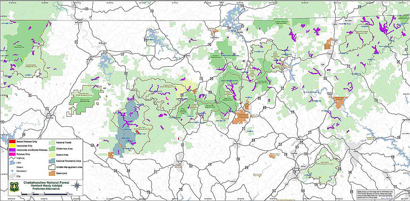
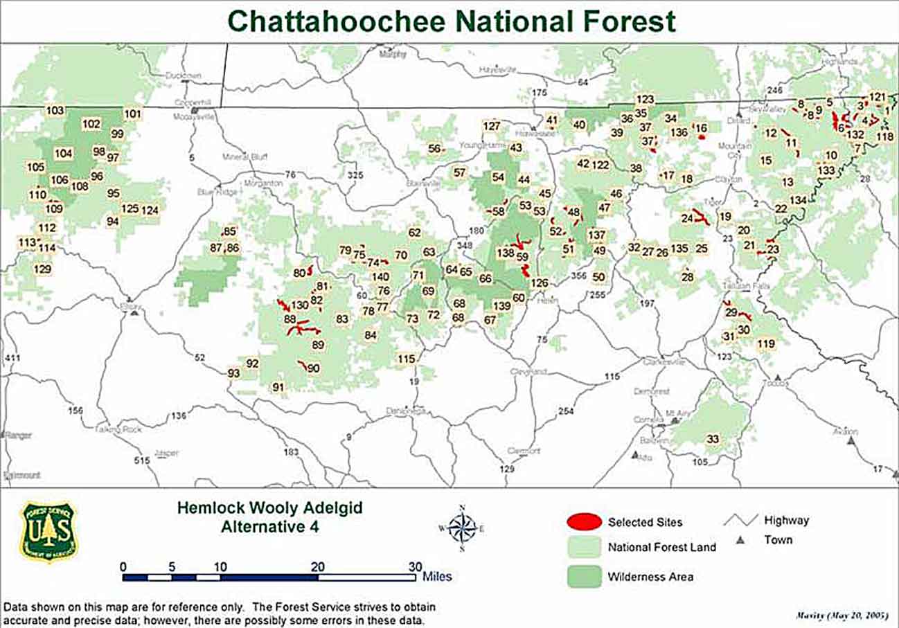
Facebook. Key stands of Hemlocks on public land (national
forests, state parks, recreation areas, etc.) are being treated with carefully managed programs of
chemical and/or biological controls. The treatment plan adopted by
the U.S. Forest Service (shown in the map and chart below) is officially called
“Alternative 4 – Modified Proposed Action.” This alternative
uses releases of predator beetles that eat Hemlock woolly adelgids to establish
long-term population control and Imidacloprid treatment to maintain genetic
reserves of Hemlocks in 144 USFS-designated Hemlock Conservation Areas covering
19,710 acres. Here is information from the
Key stands of Hemlocks on public land (national
forests, state parks, recreation areas, etc.) are being treated with carefully managed programs of
chemical and/or biological controls. The treatment plan adopted by
the U.S. Forest Service (shown in the map and chart below) is officially called
“Alternative 4 – Modified Proposed Action.” This alternative
uses releases of predator beetles that eat Hemlock woolly adelgids to establish
long-term population control and Imidacloprid treatment to maintain genetic
reserves of Hemlocks in 144 USFS-designated Hemlock Conservation Areas covering
19,710 acres. Here is information from the